Adaptive Traffic Control Systems and Methods
INTRODUCTION
A traffic intersection is a location where vehicular traffic going in different directions can proceed in a controlled manner designed to minimize accidents. Intersections with heavy traffic or fast traffic are usually controlled by traffic signals. Most of the traffic signals today can be divided into 2 categories; i.e., fixed time and vehicle actuated (VA).
Fixed time signals are set to repeat regularly a cycle of red, amber (or yellow), and green lights. Depending upon the traffic intensities at different times of the day, the timings of each phase of the cycle are predetermined. Those predetermined timings that are set to activate according to a schedule are called multiplan.
By design, multiplan serves only the average peak traffic flow at different time frames based on historical traffic flow volumes. The cycle of red, yellow, and green goes on irrespective of whether on any road, at the time, there is any traffic or not. Traffic in the heavy stream has to stop at the end of the phase, and green time is wasted serving roads with low traffic.
In conventional VA signals, in-ground loop detectors are placed at each lane for vehicle detection. The timings of the phase and cycle are changed according to traffic demand. While this system reduces the loss of green time by ending the cycle early when the demand is low and extends the green time to serve more traffic in the heavy stream, its range of detection is limited and its accuracy is highly dependent on the number of detectors installed. Aside from the increase in cost for installing more detectors, these in-ground loops also accelerate roadway deterioration, which further increases the cost due to road maintenance.
As fixed time and VA usually operate within a single intersection, the lack of coordination between adjacent intersections means that vehicles may need to stop at multiple red lights when traveling through a series of nearby intersections. This impedes traffic progression and increases traffic delays.
A good multi-intersection traffic system design will require each intersection to share traffic information with one another and have their signal timings coordinated and synchronized to produce a continuous traffic flow over several intersections in one main direction, i.e., green wave, thus promoting higher traffic loads, which most of the traffic systems in Malaysia currently lack. To achieve this, a central processing unit or computer is usually needed to process the traffic information gathered across all intersections and decide on generating new instructions to control the traffic lights.
SASCOO (Step Adaptive Split-Cycle-Offset Optimizer) is an intelligent traffic control system, designed to optimize traffic movement. SASCOO infrastructure (Figure 1) consists of multiple video recording devices, multiple local processing units, and a cloud processing unit.
When the SASCOO infrastructure is first installed, intelligent cameras are placed at the entrances of every intersection to detect the movements of all vehicles. The local PC at each intersection processes this information and sends this data to the cloud, where SASCOO algorithms are applied and optimal traffic signaling instructions are sent back to the intersections. These instructions determine the duration of green lights and the sequence of traffic movement. This process happens for every traffic light cycle, allowing SASCOO to make real-time decisions and adapt to the ever-changing demands of the traffic flow.
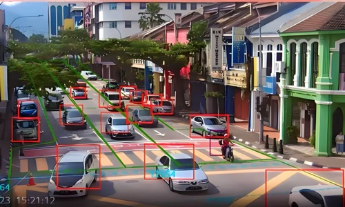
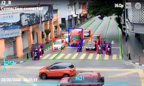
Video recording devices, i.e., cameras are deployed at each intersection to capture traffic data. Depending on the size of the intersection, extra cameras may be added. There are 2 types of cameras at each intersection, one has a stationary view of the entrance of an intersection, i.e., the area in front and behind the stop line, another one has a 360-degree rotatable view of the intersection. The former is used for capturing vehicular data such as license plate, classification and count, and traffic data such as queue, residual, and occupancy. These data are collected and processed by a local computer before sending them to the cloud for further processing. The latter is used for intersection monitoring purposes.
The recorded videos are processed in real-time using neural networks that are trained beforehand and all resulting information is stored in the cloud’s database. Vehicle detection that includes vehicle classification and the location of the vehicles is done in the camera using object detection and recognition. Vehicle count and passenger car unit (PCU) are then determined for each respective lane. License plate recognition is done by the local PC using Image-based Sequence Recognition. High-resolution (4K) cameras are used to get the license plate numbers of the vehicles. By matching the license plates across different intersections, the journey time and speed of a vehicle can be estimated. Based on the historical behavior of the intersections, SASCOO algorithm generates a dedicated signal timing plan, i.e., multiplan for each intersection and coordinates the green lights along the arterial roads to produce green wave progressions.
The other pieces of information provided by the cameras are the queue and residual. The queue is the number of vehicles waiting at the intersection during red. The queue used here refers to the queue that is ready to leave the intersection, i.e., right before the start of green. The residual, on the other hand, refers to the remaining queue at the end of green, i.e., the queuing vehicles that are unable to pass through the intersection after the duration of green. SASCOO algorithm uses this information to make adaptations to the multiplan to meet the latest traffic condition. The offset is the time from when a signal turns green until the succeeding signal turns green along a series of intersections. Compared with a preceding signal, a positive offset means that the succeeding signal turns green later; a negative offset means that the succeeding signal turns green sooner; a zero offset means that both the signals turn green at the same time.
This offset is adjusted to make the traffic pass through several intersections without the need to stop, i.e., green wave. When the queue is long (Figure 2A), the offset is usually negative, and it represents (relatively) the time needed to release the queue at the succeeding intersection so that the incoming vehicles traveling from the preceding intersection are not slowed down by the queue; When the queue is short (Figure 2B), the offset is usually positive, and it represents the journey time of the vehicles traveling from the preceding intersection to the succeeding intersection. When the residual is high (Figure 2A), where demand exceeds available capacity, the green time is extended to allow more vehicles to be released, effectively increasing the cycle length; when the residual is low (Figure 2B), the green time remains unchanged.
The cameras also provide the occupancy of the vehicles on the road. Occupancy in this context means the number of moving vehicles detected on each lane of the road. When the occupancy reading is constantly high (Figure 3A), a high volume of vehicles is being released, thus the green time is fully utilized; when the occupancy reading is low (Figure 3B), the queue has been completely discharged, and the green time is being under-utilized from this point onwards. SASCOO algorithm measures the duration for which the occupancy is low and decides to either reduce the green time for that phase, while effectively reducing its cycle length, or transfer it to other phases that need it.


Problem Statement:
Fixed time and VA signals that use in-ground loop detectors are unable to provide smooth traffic progression for vehicles traveling through a series of intersections.
Summary of the Invention:
A method of coordinated traffic signal control across multiple intersections
Key Features of the Invention:
- A method of coordinated traffic signal control across multiple intersections.
- A system comprised of cameras coupled to a deep learning model to detect, locate and classify the vehicles.
- Each detected vehicle is assigned a unique identifier for tracking purposes.
- An automatic license plate recognition system to calculate the journey time, waiting time, and delays of the vehicles.
- An adaptive traffic signal system to process the quantity, location, and movements of the vehicles, i.e., queue, residual, occupancy, and journey time, in real-time to generate new coordinated signal timing plans that alter the offset, split, and cycle length across all connected intersections.
- A method of producing green wave progression along an arterial road across a series of intersections.
- Information such as, but not limited to, residual, queue, occupancy, journey time, waiting time, origin-destination, classification, PCU, and license plate are stored in the database.
Patent Search:
- US8050854B1 – Chandra et al. – Sep. 24, 2008 Adaptive Control Systems and Methods
- US8103436B1 – Chandra et al. – Sep. 24, 2008 External Adaptive Control Systems
- US10490066B2 – Green et al. – Dec. 29, 2016 Dynamic Traffic Control
- US11100336B2 – Malkes et al. – Aug. 8, 2018 System and Method of Adaptive Traffic Management at an Intersection
- US10373489B2 – Malkes et al. – Jul. 9, 2018 System and Method of Adaptive Controlling of Traffic Using Camera Data
- US10373489B2 – Price et al. – Aug. 8, 2018 System and Method of Adaptive Controlling of Traffic Using Zone Based Occupancy
Featured Table
![]()
| Features | Present Invention | 1 | 2 | 3 | 4 | 5 | 6 |
|---|---|---|---|---|---|---|---|
| A method of coordinated traffic signal control across multiple intersections | ✔ | ✔ | ✔ | ✔ | ✔ | ✔ | ✔ |
| A system comprised of cameras coupled to a deep learning model to detect, locate and classify the vehicles | ✔ | ❌ | ❌ | exter-nal only | exter-nal only | exter-nal only | exter-nal only |
| Each detected vehicle is assigned a unique identifier for tracking purposes | ✔ | ❌ | ❌ | ❌ | track-ing only | ❌ | ❌ |
| An automatic license plate recognition system to calculate the journey time, waiting time, and delays of the vehicles | ✔ | ❌ | ❌ | ❌ | ❌ | ❌ | ❌ |
| An adaptive traffic signal system to process the quantity, location, and movements of the vehicles, i.e., queue, residual, occupancy, and journey time, in real-time to generate new coordinated signal timing plans that alter the offset, split, and cycle length across all connected intersections | ✔ | queue only | vague-ly | ❌ | ❌ | occu-pancy only | |
| A method of producing green wave progression along an arterial road across a series of intersections | ✔ | ✔ | ✔ | vague-ly | ❌ | ❌ | ❌ |
| Information such as, but not limited to, residual, queue, occupancy, journey time, waiting time, origin-destination, classification, PCU, and license plate are stored in the database | ✔ | ✔ | ✔ | ✔ | ✔ | ✔ | ❌ |
SASCOO ADAPTIVE GREENWAVE
SASCOO (Step Adaptive Split Cycle Offset Optimizer) is an AI system that enables the traffic junctions to continuously distribute green light time equitably for all traffic movement.
SASCOO refers to an artificial intelligence software that was used as part of the AdvanCTi smart traffic management system implemented by LED Vision in Pasir Gudang and Ipoh.
Here are some key points about SASCOO:
- It is described as an “AI Traffic Optimizer” that is trained on historical traffic data.
- It collects real-time data from sensors and cameras installed at traffic junctions.
- Using the real-time data, it dynamically optimizes traffic light timing and phases to improve traffic flow.
- It implements adaptive signal control algorithms to adjust split times, cycle lengths, etc.
- This optimization by SASCOO reduced congestion and improved traffic efficiency in Pasir
- Gudang and Ipoh during the proof of concept projects.
- The architecture diagram shows SASCOO as a core software component of the AdvanCTi platform.
- SASCOO optimization developed in-house. SASCOO has been submitted and patent pending by LED Vision Sdn Bhd on 8 April 2022 with application number PI2022002279 (MyIPO)